RemScan for Agriculture
Ziltek is currently developing a suite of Applications for Agriculture


Ziltek is currently developing a suite of Applications for Agriculture

BACKGROUND
Agriculturists are increasingly relying on data to guide land management practises. Further to this, global climate change is providing economic incentives for land owners to increase soil organic carbon stocks in soils to mitigate the amount of CO2 in the atmosphere.
In response to these trends, Ziltek is leveraging their expertise in hand-held Mid-Infrared (MIR) soil measurement to develop a suite of predictive models for analysing the properties of agricultural soils. Hand-held field measurement promises in-expensive, accurate, real-time measurements of a host of important agricultural parameters. Thus, empowering land owners and agronomists to confidently make important decisions in less time at lower cost.
CALIBRATION MODELLING
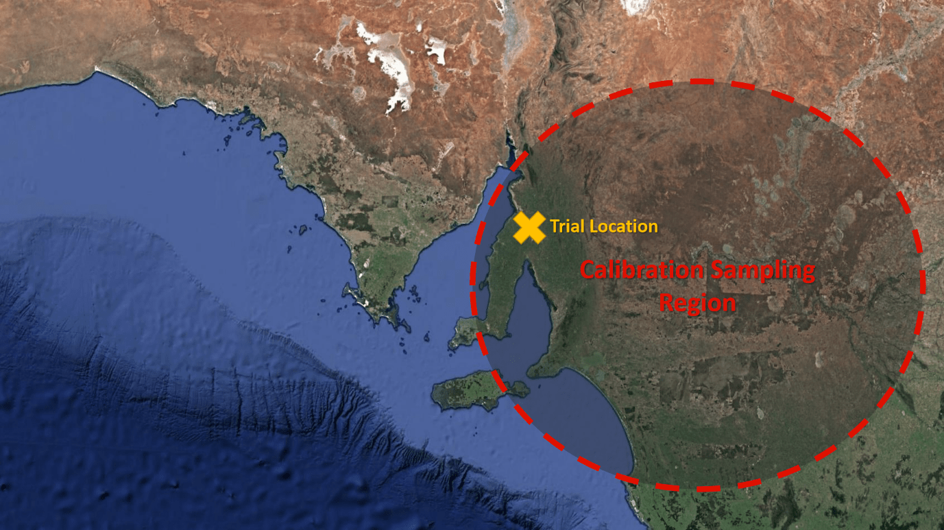
Ziltek conducted a proof-of-concept study to determine the viability of in-field MIR soil measurements. Regression models were generated from a dataset of approximately 1,000 soil samples collected from across regional South Australia (see Figure 1).
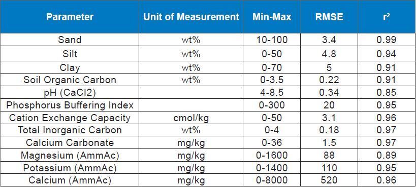
The samples were also measured at an accredited laboratory (APAL) for the following properties:
• Texture (sand/silt/clay)
• pH (CaCl2)
• Soil Organic Carbon
• Phosphorus Buffering Index
• Cation Exchange Capacity
• Total inorganic carbon
• Calcium Carbonate
• Magnesium (AmmAc)
• Potassium (AmmAc)
• Calcium (AmmAc)
Laboratory and spectral data were processed in combination using multivariate and machine learning techniques to produce calibrations for each of the measured properties. The data was split into training and validation subsets (70:30) based on spectral variance using the Kennard-Stone selection method. Calibrations were optimised based on minimising the prediction uncertainty on the validation set. The details of these calibrations are summarised in Table 1.
FIELD TRIAL
Subsequently a field trial was carried out to evaluate the accuracy and utility of these calibrations. The trial site was chosen to be within the calibration sample region to ensure that the soils under study were mineralogically similar to those in the calibration set. The chosen paddock was a 320 acre area of land that has previously been characterised by others using multiple techniques. As a result, there was a preestablished grid of 132 sample locations distributed at 100 metre intervals. In-field scanning was carried out at each of the sample locations. Before measuring, loose plant matter and gravel were scraped away from the soil surface, and the soil was tamped flat. Five replicate measurements were obtained within 5 cm of each other at each sample point.
VALIDATION
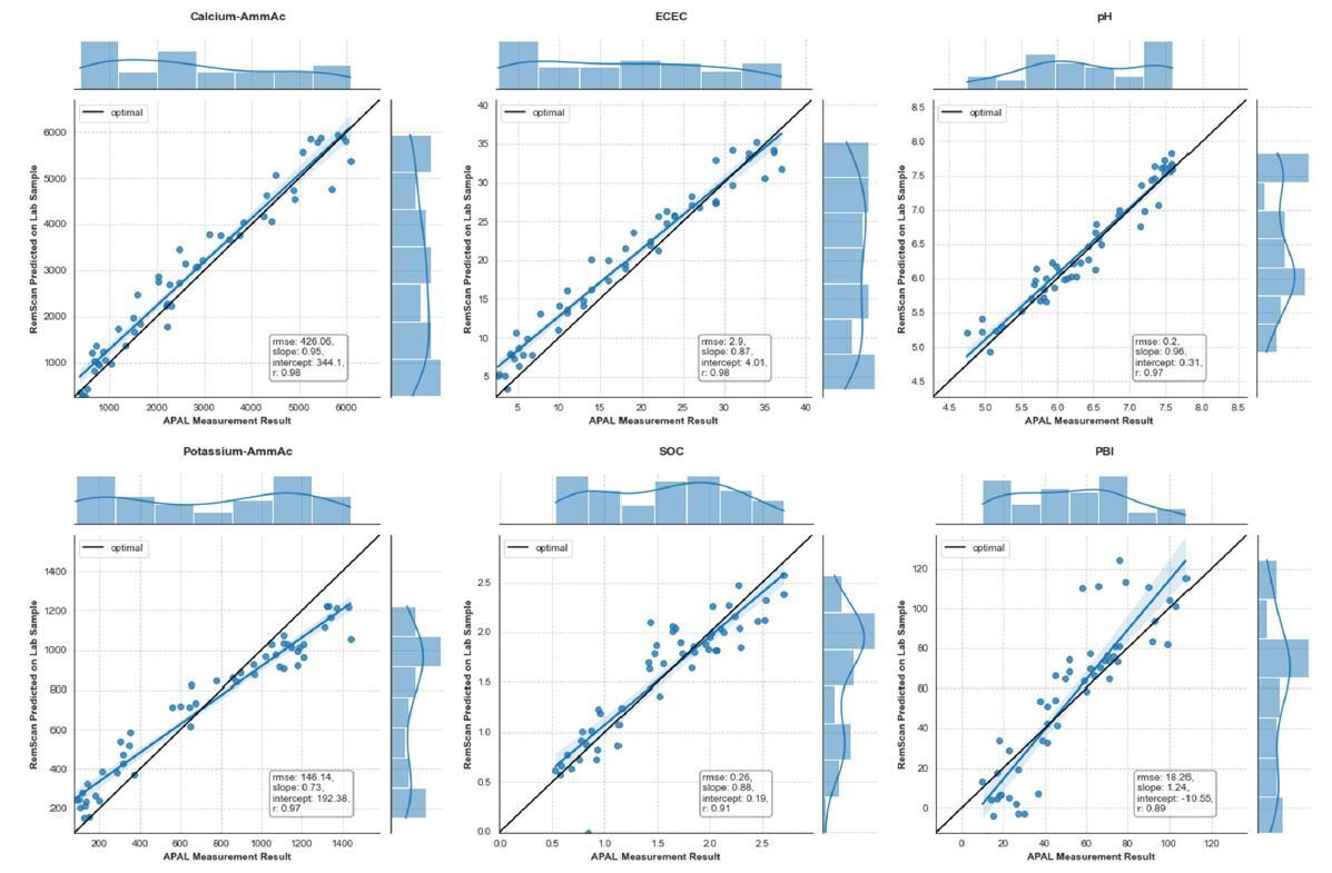
A set of 40 validation samples were selected and sent to an accredited laboratory (APAL) for analysis of their properties. Figure 3 shows the correlation between in-field measurement by RemScan and laboratory assays. While there is more work to be done in terms of improving the predictive accuracy of the calibrations, we believe the results are encouraging.
CONCLUSION
Ziltek has shown that in-field MIR measurements of soil properties can provide reliable data at a fraction of the cost of traditional laboratory measurements. Each 20 second scan provides all 12 of the calibrated parameters simultaneously, which means that RemScan is providing up to $100 of soil information per scan. Furthermore, this data is obtained in-field in real time.
This work is on-going and is now focused on increasing the size and variability of the training dataset and in further demonstrating the utility of in-field scanning in the context of precision agriculture and soil carbon mapping and monitoring.
If you are interested in working with Ziltek on these activities please contact us